What Is LiDAR?
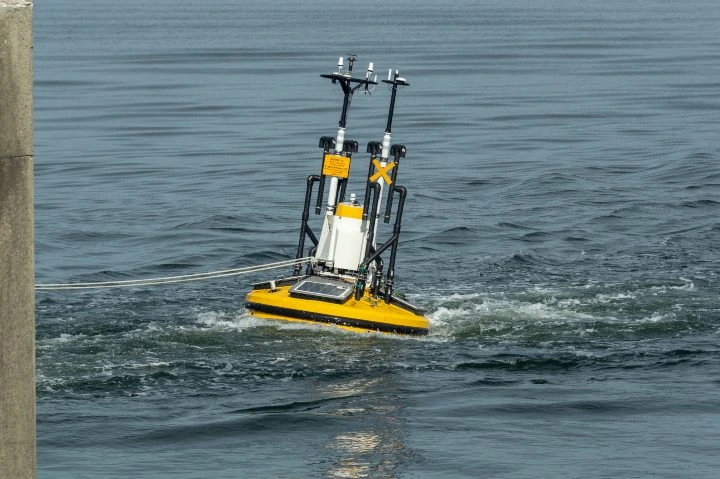
LiDAR, short for Light Detection and Ranging, is a sophisticated remote sensing technique that measures distance by firing high-intensity laser pulses at targets and analyzing the reflected signals. It essentially uses light energy to gather precise spatial data, which can then be transformed into highly accurate 3D models. LiDAR instruments operate by emitting a laser pulse toward an object, capturing the time it takes for the light to return, and computing the distance based on the speed of light. This data helps generate detailed 3D representations of landscapes, structures, or any other surfaces being scanned. Whether it’s mapping terrain, inspecting infrastructure, or aiding autonomous vehicles, LiDAR plays a critical role in modern applications. LiDAR technology is versatile, finding applications across various industries, including aviation, construction, agriculture, and robotics. Its ability to work in challenging environments, such as underground mines or dense forests, has revolutionized how we approach complex tasks that were once hazardous or impossible for humans to complete alone. At its core, LiDAR combines advanced optics with powerful lasers to capture intricate details about the physical world. It began as an experimental tool in the 1960s, initially used for mapping small rivers and streams. Over decades, advancements in GPS and computing power have expanded its capabilities exponentially, enabling large-scale mapping projects and real-time data processing. An Ouster OS0-128 LiDAR sensor Early LiDAR systems were bulky and expensive, requiring specialized aircraft for deployment. Today, thanks to technological miniaturization, LiDAR is now compact enough to fit into smartphones and drones, making it accessible to a broader audience. Recent innovations even allow LiDAR to create 3D models from distances of up to 15 feet, showcasing its evolving versatility. LiDAR sensors integrated with visual sensors on a smartphone With such rapid progress, it's fascinating to consider how far LiDAR has come since its inception. But how does it actually work under the hood? Regardless of whether it’s attached to a drone, mounted on a vehicle, or integrated into handheld devices, all LiDAR systems function similarly. They emit precise laser pulses toward objects and record the returning signals to calculate distances. Think of it as radar but using light instead of radio waves. Each LiDAR setup consists of several key components: The laser emits focused beams of light at specific wavelengths depending on the application. For instance, some lasers are optimized for detecting vegetation while others are better suited for urban environments. Regardless of the type, these lasers play a crucial role in sending out signals that bounce off surfaces and return to the sensor. The scanner receives the reflected laser pulses and ensures they're processed correctly. Depending on the intended use case, scanners may employ different optical configurations, such as beam splitters or hole mirrors, to optimize signal reception. For accurate measurements, LiDAR systems need precise positional data. Most modern LiDAR devices incorporate advanced GPS modules alongside inertial measurement units (IMUs) to ensure reliable localization and orientation tracking. Other factors like battery life, data storage capacity, and environmental adaptability also influence the design of LiDAR payloads, particularly when tailored for specific tasks. The entire process—from firing a laser pulse to interpreting its return—can be summarized mathematically using the following equation: d = c * t / 2 In this equation: d represents the distance c denotes the speed of light t stands for the round-trip travel time of the laser pulse Compared to traditional surveying methods, LiDAR offers numerous advantages that make it indispensable in today's world. First and foremost, LiDAR provides unparalleled accuracy, capable of resolving minute details down to millimeter precision. Unlike photogrammetry, which relies heavily on image synthesis, LiDAR captures raw data directly, reducing computational overhead and enhancing reliability. Another significant advantage lies in LiDAR's capability to function effectively in low-light conditions or obscured environments. Traditional cameras struggle in dimly lit settings, whereas LiDAR systems excel due to their reliance on infrared lasers. This feature proves invaluable in scenarios involving rescue operations, crime scene analysis, or infrastructure inspections where visibility might be limited. Additional benefits include: Automation of repetitive tasks Wide applicability across diverse domains Cost efficiency driven by continuous innovation LiDAR instruments vary widely based on several criteria, including laser type, orientation, and platform type. One fundamental classification divides LiDAR systems into topographic and bathymetric categories: Topographic LiDAR: Utilizes near-infrared lasers to map landforms, urban landscapes, and natural features. Bathymetric LiDAR: Employs green light capable of penetrating water to measure seabeds, riverbeds, and coastal zones. LiDAR systems can also be categorized based on their orientation relative to the subject being scanned: Nadir-oriented: Looking downward, often seen in altimetry applications. Zenith-oriented: Facing upward, commonly used in atmospheric research. Lateral-oriented: Pointing sideways, frequently employed in automotive applications. Finally, LiDAR instruments can be classified according to the platform they operate from: Aerial LiDAR: Installed on drones, helicopters, planes, or satellites for aerial surveys. Terrestrial LiDAR: Ground-based systems for indoor/outdoor mapping. This categorization helps differentiate between various implementations of LiDAR technology, highlighting their unique strengths and applications. Having explored the basics of LiDAR, let us delve deeper into its practical applications across multiple sectors. In emergency situations, such as vehicle collisions or natural disasters, LiDAR enables rapid scene assessment. Paramedics and first responders can quickly gather critical information about the environment, helping prioritize life-saving actions over logistical concerns. Furthermore, detailed maps produced by LiDAR serve as irrefutable evidence during legal proceedings, ensuring justice prevails. Farmers benefit immensely from LiDAR technology by optimizing crop yields, monitoring irrigation systems, and managing livestock movements. Advanced LiDAR setups even allow farmers to track individual pests or monitor soil moisture levels remotely, empowering smarter agricultural practices. Conservationists leverage LiDAR to monitor ecosystems, track deforestation rates, and plan sustainable development initiatives. High-resolution 3D models derived from LiDAR scans assist policymakers in making informed decisions regarding land management and biodiversity preservation. Archaeologists have discovered ancient ruins hidden beneath dense foliage using LiDAR technology. For example, researchers recently uncovered remnants of a Maya civilization in Guatemala by analyzing aerial LiDAR images. Such discoveries highlight LiDAR's potential to rewrite history and expand our understanding of past civilizations. Municipalities utilize LiDAR to design safer cities, improve public transit networks, and enhance disaster preparedness plans. By creating accurate digital twins of urban areas, planners gain unprecedented insights into population distribution, traffic patterns, and infrastructure vulnerabilities. A LiDAR sensor deployed on an aquatic platform These examples barely scratch the surface of LiDAR's immense possibilities. From healthcare diagnostics to entertainment industries, the opportunities for integrating LiDAR continue to grow, promising transformative changes across countless disciplines. Automatic Cutting And Sewing Machine
Automatic feeding, automatic correction, automatic mark tracking, hand hole, riser vent, automatic counting,batch sending,disconnection alarm,fault and automatic stop when finding connecting of woven bag.
The machine is suitable for fertilizer bags,rice bags,flour bag,putty powder bag,single colored bag,double sides colored bag and laminating bag etc.
Automatic Cutting And Sewing Machine,Liner Bags Cutting And Sewing Machine,Liner Bags Sewing Machine,Pp Woven Bags Cutting And Sewing Machine Zhejiang Sanlong Universal Machinery Co.,Ltd. , https://www.sanlongco.comWhat Exactly Is LiDAR?
 Flyability's Elios 3's LiDAR sensor glowing green as it navigates a water treatment plant
Understanding LiDAR Technology

The Science Behind LiDAR
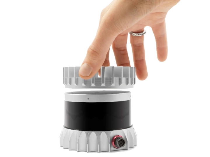
 An infrared image showing a LiDAR sensor | Credit: Ouster
1. The Laser
2. The Scanner
3. Global Positioning System
LiDAR Equation
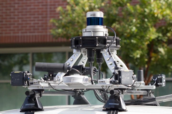
 An Ouster LiDAR sensor mounted on a vehicle
Advantages of Using LiDAR
 A LiDAR sensor mounted on an autonomous vehicle
Categorizing Types of LiDAR
Laser Type
Orientation
Platform
Practical Applications of LiDAR
1. Emergency Response
2. Agriculture
3. Environmental Protection
4. Archaeology
5. Urban Planning