What Is LiDAR?
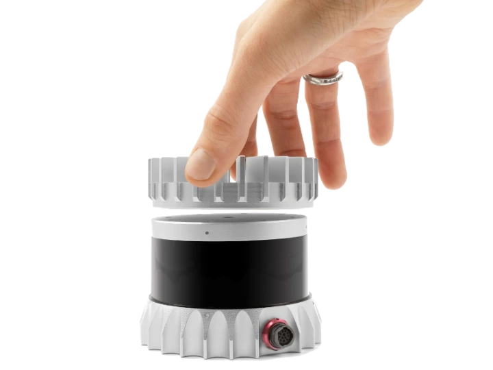
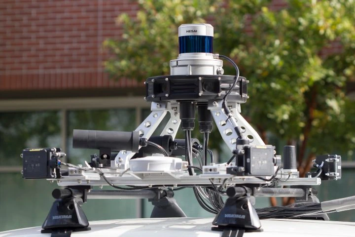
LiDAR, short for Light Detection and Ranging, is a cutting-edge remote sensing technology that leverages high-powered lasers to measure distances and gather precise 3D data. It essentially works by emitting a laser pulse toward an object and analyzing the time it takes for the reflection to return, along with the intensity of the light, to compute the exact distance and position of the object. This data is then translated into highly accurate 3D models, making LiDAR invaluable across numerous industries. From mapping landscapes to aiding autonomous vehicles, the technology has evolved dramatically since its inception in the 1960s. Flyability's Elios 3 showcases a LiDAR sensor glowing green as it navigates a water treatment facility. With its versatility, LiDAR is deployed in various sectors, including aviation, construction, agriculture, and even archaeology. Its ability to capture data in challenging environments—such as dark caves or dense forests—has made it a game-changer in industries where precision and safety are paramount. LiDAR's journey began in the early 1960s, shortly after the invention of lasers. Initially, it was primarily used for aerial mapping, with early systems mounted on planes. Over the decades, advancements in GPS and computing power have transformed LiDAR from a niche tool to a mainstream solution. An Ouster OSO-32 LiDAR sensor captures intricate details with its advanced optics. In the 1980s, GPS integration allowed LiDAR to become a key player in large-scale mapping projects. However, early systems were bulky, costly, and often limited in scope. Today, thanks to technological miniaturization and reduced costs, LiDAR sensors are now found in consumer products like smartphones, enabling users to create 3D models from distances of up to 15 feet. No matter the platform—a drone, a car, or a handheld device—LiDAR operates on the same fundamental principle. A high-powered laser emits pulses of light toward an object. The returning reflections are captured and analyzed to determine the distance and position of the object. Unlike radar or sonar, which use sound or radio waves, LiDAR relies on light pulses. This allows it to achieve remarkable accuracy, even in challenging conditions. Key components of a LiDAR system include: Lasers vary in wavelength and power, depending on the application. For instance, topographic LiDAR uses near-infrared light, while bathymetric LiDAR employs green light to penetrate water surfaces. Scanners are responsible for collecting the reflected light pulses. They often feature advanced optics to ensure precise measurements. Accurate positioning is crucial for LiDAR systems. Most modern systems integrate GPS and inertial measurement units (IMUs) to ensure precise spatial data. The core calculation behind LiDAR involves a simple yet powerful formula: d = c * t / 2 Where d is the distance, c is the speed of light, and t is the time of flight. LiDAR offers several advantages over traditional surveying methods: A LiDAR sensor integrated into a self-driving vehicle provides real-time obstacle detection. LiDAR systems can be classified based on factors such as laser type, orientation, and platform. Two primary categories are topographic and bathymetric LiDAR. Topographic LiDAR uses near-infrared light for land mapping, while bathymetric LiDAR penetrates water surfaces to measure depths. LiDAR systems can also be categorized by their orientation: looking down (nadir), up (zenith), or sideways (laterally). Another classification is based on the platform: aerial, terrestrial, or mobile. Each type serves specific purposes, from satellite-based mapping to drone-assisted inspections. LiDAR technology finds applications in a variety of fields: LiDAR systems enable rapid scene analysis at accident sites, providing critical data for first responders and legal proceedings. Farmers leverage LiDAR to monitor crop health, manage irrigation systems, and track livestock movements. LiDAR has uncovered ancient structures buried beneath dense vegetation, revolutionizing archaeological research. Self-driving cars rely on LiDAR for obstacle detection, navigation, and collision avoidance. As LiDAR continues to evolve, its potential applications seem limitless, promising a future where precision meets innovation in countless ways. Middle Speed Flat Film Tape Extruder We have strong technical force, a perfect CAD network, CAPP networks and a CAD development system, with all kinds of large-scale precise equipment, high-medium machining equipment, testing equipment, advanced production technology, a quality assurance system and steady product quality. The "Three-dragon" brand complete set of equipment for Middle Speed Flat Film Tape Extruder is sold throughout the country and exported to overseas markets, and now it covers more than 30 countries and regions, such as Russia, Vietnam, Indonesia, Malaysia, Bangladesh, Uzbekistan, Ethiopia, Congo, Nigeria, Syria, etc. Middle Speed Flat Film Tape Extruder,Pp Woven Extruder Tape Produce Machine,Pp Woven Extruder Tape Machine,Woven Extruder Tape Machine Zhejiang Sanlong Universal Machinery Co.,Ltd. , https://www.sanlongco.comUnderstanding LiDAR Technology

History and Evolution of LiDAR
How LiDAR Works

1. The Laser
2. The Scanner
3. The Navigation System
LiDAR Formula
Advantages of LiDAR
Types of LiDAR
Laser Type
Orientation
Platform
Applications of LiDAR
1. Emergency Response
2. Agriculture
3. Archaeology
4. Autonomous Vehicles